


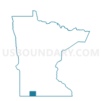
Rost Twp. Voting District, Jackson County, Minnesota
About
Outline

Summary
| Unique Area Identifier | 602678 |
| Name | Rost Twp. Voting District |
| County | Jackson County |
| State | Minnesota |
| Area (square miles) | 36.10 |
| Land Area (square miles) | 36.10 |
| Water Area (square miles) | 0.00 |
| % of Land Area | 100.00 |
| % of Water Area | 0.00 |
| Latitude of the Internal Point | 43.63113450 |
| Longtitude of the Internal Point | -95.27530050 |
Maps

Graphs
Select a template below for downloading or customizing gragh for Rost Twp. Voting District, Jackson County, Minnesota


Neighbors
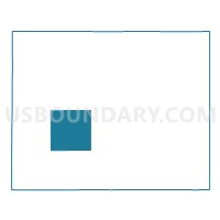
Neighoring Voting District (by Name) Neighboring Voting District on the Map
- Alba Twp. Voting District, Jackson County, MN
- Ewington Twp. Voting District, Jackson County, MN
- Heron Lake Twp. Voting District, Jackson County, MN
- Hunter Twp. Voting District, Jackson County, MN
- Minneota Twp. Voting District, Jackson County, MN
- Round Lake Twp. Voting District, Jackson County, MN
- Sioux Valley Twp. Voting District, Jackson County, MN
- West Heron Lake Twp. Voting District, Jackson County, MN
Top 10 Neighboring County Subdivision (by Population) Neighboring County Subdivision on the Map
- Heron Lake township, Jackson County, MN (333)
- Minneota township, Jackson County, MN (259)
- Ewington township, Jackson County, MN (244)
- Hunter township, Jackson County, MN (224)
- Rost township, Jackson County, MN (211)
- Sioux Valley township, Jackson County, MN (192)
- West Heron Lake township, Jackson County, MN (181)
- Alba township, Jackson County, MN (170)
- Round Lake township, Jackson County, MN (166)